 New York
Algonquin Peak
Introduction
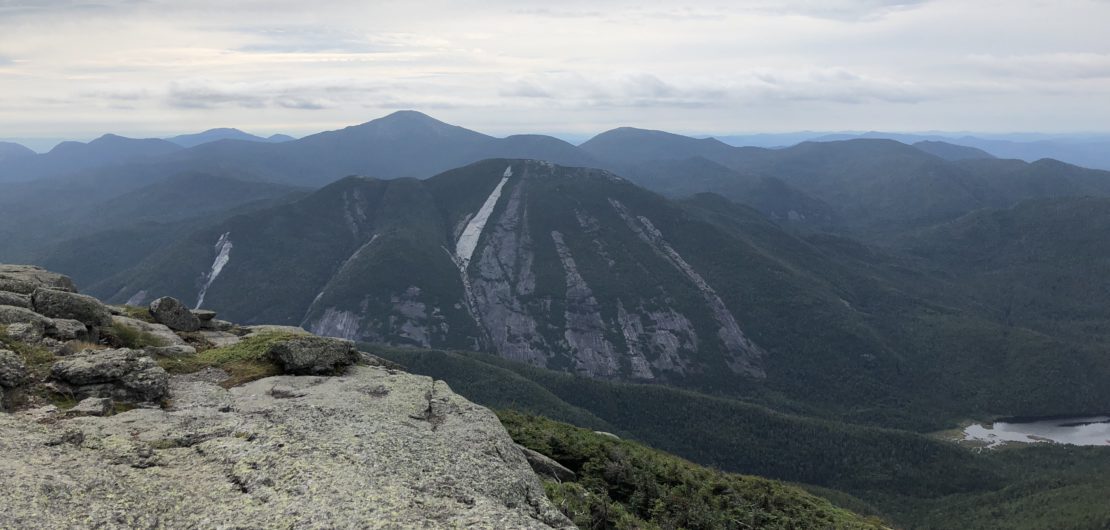
At an altitude of 1559 meters (5114 ft), Algonquin peak is the second highest mountain of the Adirondacks. Located in the heart of the High Peak region, this imposing mountain offers hikers an undeniable physical challenge with its steep and rocky trail. The summit offers a 360 degree view of the Adirondacks and nearby valleys. It is a hike not to be missed. C’est Notre Monde will show you the way.
3D interactive map
>
To enjoy your hike, you must:
Be equipped: For the ascent of Mount Algonquin, you will need hiking shoes with a good grip. The path is very rocky and at certain points completely covered by smooth, slippery boulders. Hiking poles are useful on a large part of the trail. Be mindful to bring enough water (3L) and food (especially if you decide to loop through Colden Lake). Finally, we suggest you bring a raincoat or windbreaker for when you reach the summit.
Be informed: A Ranger’s cabin is located in the parking lot. Speak with the Rangers and share your route. They will inform you of the weather conditions and the state of the trails. You can also purchase equipment, maps and rent crampons during the winter months.
Parking: There is a fee for parking. Only cash accepted.
The Hike
The hike begins on the Van Hoevenberg Trail. Sign in on the trail register and begin your hike! The first 1.5 km (0.9 mi.) are flat and allow you to cross the forest pretty quickly. At the first intersection, a sign provides directions for several peaks, including “Algonquin Peak”. The trail begins with a steep climb and continues this way until you reach the top, so pace yourself. After 2.3 km (1.5 mi.), you will come to a charming waterfall named “Macintyre Falls”. Wild camping sites are located here for those wishing to spend the night. Continue your ascent until the next intersection about 1 km (0.6 mi.) further. If you are up for it, at this point you have the opportunity to climb the Wright Peak (1398 meters or 4586 ft) by turning right (1 km or 0.6 mi. round trip from your current position).
For the Algonquin Summit, continue straight ahead. Several passages during this ascent are slippery as the trail passes directly over large boulders. Be cautious on the rocks, especially when wet. You will leave the forest quickly and finish your ascent on open ground with a superb panorama of the region. Please do not deviate from the trail as you approach the summit. The alpine vegetation is in the process of being regenerated and must be protected. Once at the end of the trail you will have a spectacular view of the region. This includes the imposing Mount Marcy, Keene Valley, White Mountain and many other mythical peaks of the Adirondacks. It is breathtaking.
Tip: This is a very popular hike in the Adirondacks. We advise you leave early in the morning, before sunrise is best
Once at the summit, two options are available to you: You can return the way you came (about 6 km or 3.9 mi. to get to the parking lot), or you can continue to lake Colden to achieve a magnificent but strenuous loop of 11.5 km (7.2 mi.).
If you choose the loop, continue on the Algonquin summit trail in the direction of Iroquois Peak. After 500 meters, you will find yourself at an intersection: Turn left down to Colden Lake. This very steep and rocky path should not be taken lightly. Rarely maintained and poorly marked in some places, the descent is filled with obstacles (rocks and fallen trees) so take your time and pay attention to your foot placement. Indeed, some sections of this trail look abandoned. After a descent of 2.8 km (1.75 mi.), a steep 700 meters (2300 ft) from the peak, you will join the Lake Colden Trail. Veer left to join the Avalanche Pass Trail and follow the Lake.
These trails are also quite demanding and include scaling fallen tree trunks, jumping stones on the lake shore, and using pre-installed ropes to help climb rock faces. All of which add to the charm and challenge of this trail.
The lake itself is beautifully situated in Avalanche pass, a name that requires no explanation as you lay eyes on the surrounding rock walls of Algonquin and Mount Colden.
Once past the lake, you will quickly reach Marcy Dam (3.2 km or 2 mi.). Follow the Van Hoevenberg Trail to the Adirondack lodge parking lot (about 4 km or 2.4 mi.). Do not forget to sign out in the trail register.
TO KNOW
Interest:
Difficulty:
(round-trip)
(lake colden loop)
Distance
12 km / 7.6 miles (lake Colden loop)
18 km / 11.2 miles (boucle du lac Colden)
Elevation
1559 meters
Height difference
907 meters / 2975 feet
Useful informations
See on Caltopo (detailed)
See on Google Maps (basic)
Useful links
Website: http://www.lakeplacid.com/do/hiking/algonquin-mountain
Parking: https://goo.gl/maps/8dXU8ypqjs92
Weather forecast: https://www.mountain-forecast.com/peaks/Algonquin-Peak/forecasts/1559