 New York
Mount Colden
Introduction
Located in the middle of the High Peaks, Mount Colden is the 11th highest peak in the Adirondacks. At its 1437 meters (4714 ft), you will have a breathtaking view the most popular mountains in the region: Mount Marcy and Mount Algonquin.
In fact, Mount Colden is situated just in between the two. The path we recount will take you through charming forests, rivers and lakes and includes two peaks, which will make this hike worth your while.
3D interactive map
Things to know
To enjoy your hike, you must:
Be equipped: Bring hiking shoes with good grip. The trail is very rocky in some areas and it is not uncommon to slip on smooth rocks. Hiking poles can help keep a good pace for long distances. Sufficient water (3L) and food is always recommended. Finally, take a raincoat and/or windbreaker for the summit.
Be informed: A Ranger’s cabin is located in the parking lot. Speak with the Rangers and share your route. They will inform you of the weather conditions and the state of the trails. You can also purchase equipment, maps and rent crampons during the winter months.
Parking: There is a fee for parking. Only cash accepted.
The Hike
From the parking lot, register in the hikers register at the start of the Van Hoevenberg Trail. Follow this trail for about 1.5 km (0.93 miles) until you meet an intersection with a sign indicating the direction of Mount Marcy. After 2 km (1.24 miles) you will arrive at Marcy Dam, a large open space with a river. From here you can see Mount Colden in the distance. Follow the path on the left to reach a bridge and cross the river to find a second hiker registration station. Register and continue on the Avalanche Pass Trail (follow the signs for Lake Colden). After 1.6 km (1 mile), you will meet another intersection. Turn left following the direction of Lake Arnold and Mount Colden. The trail, relatively flat up until this point, begins to climb and stays that way until you reach the top. So pace yourself and save your strength! 1.6 km (1 mile) further, a new intersection indicates the summit of Colden by continuing straight ahead. Continue in this direction and Lake Arnold, a charming body of water lost in the forest at an altitude of 1150 meters (3773 ft), will greet you. Take the Morgan Porter Trail for your final ascent of approximately 1.3 km (1.86 mile).
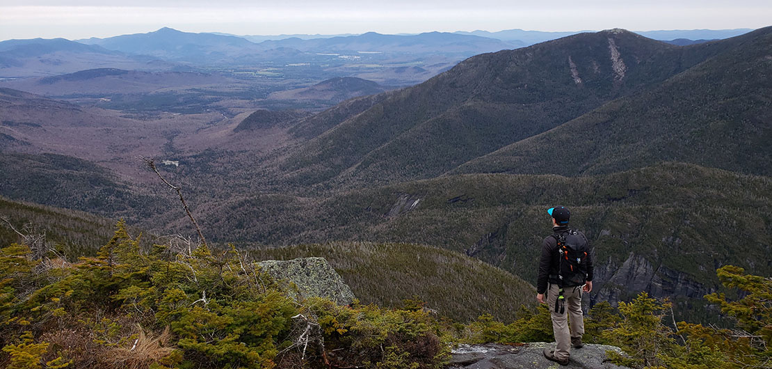
Some passages are very steep, so take your time. Near the summit, you will leave the forest cover to find yourself at the North Peak of Mount Colden. The view showcases Mount Marcy on one side, Algonquin on the other, as well as the highest peaks of the Adirondacks, such as Mount Gothics. For the summit, continue on the path which will first descend before climbing another 500 meters (1640 ft). You will pass under a pierced rock to reach the top of Mount Colden.
The summit is only partially uncovered from the trees but the view of Mount Algonquin is sublime. You will not see it better elsewhere. Below you will also see both Colden and Avalanche Lake.
Tip: The summit of Mount Colden is not completely uncovered by trees. We advise you to take advantage of the neighboring North Peak on Mount Colden which offers a more beautiful panorama
After appreciating the view, retrace your steps. 9.65 km (6 miles) to return to where you started.
TO KNOW
Interest
Difficulty
Distance
19.3 km / 12 miles
Duration
9 h
Elevation
1437 meters / 4715 feet
Height Difference
915 meters / 3000 feet
Infos utiles
The hike in 3D
See on Caltopo (detailed)
See on Google Maps (basic)
Useful links
Website: https://www.lakeplacid.com/do/hiking/mount-colden
Parking: https://goo.gl/maps/5GjFFeZXvbwLmoNu8
Weather forecast: https://www.mountain-forecast.com/peaks/Colden/forecasts/1437