 New York
Nippletop Mountain
Introduction
Yes, you read that correctly. Seen from a certain angle, it does indeed look like a nipple. From a height of 1,408 meters (4619 ft), this mountain offers a unique panorama: on one side the superb Adirondack range and on the other the imposing Dix Mountain. On your way to the summit, you will have the opportunity to reach the peaks of two other mountains (Bear Den at 1043 meters / 3422 ft and Dial at 1225 meters / 4020 ft) all while crossing a ridge dotted with superb views. So spare your efforts and prepare yourself. C’est Notre Monde will take you on the long, demanding trail to Nippletop!
3D interactive map
Things to know
To enjoy your hike, you must:
Be equipped: This is a long hike, so good hiking shoes are important. During the winter months, snowshoes and crampons are necessary. Temperatures can drop quickly at the peaks, so have an extra layer kept dry in your bag. And of course, 2 to 3 liters of water and food is a must. For added comfort, bring a thermos with tea or coffee for those cold winter days.
Be informed: An information board is located at the start of the hike on Lake Road. Consult it carefully before getting started!
Parking: Parking is free, but often very busy. If it is full, you will have to drive several hundred meters to find a parking lot.
The Hike
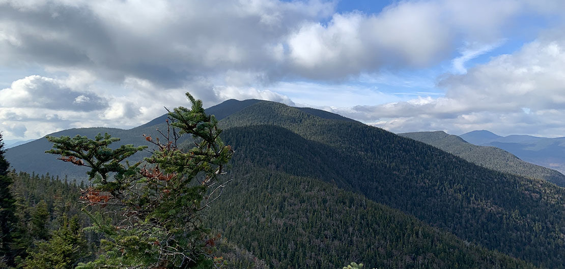
Once parked, follow Ausable Road towards the Ausable Golf Club. Continue left 1 km (0.6 miles) down Lake Road to the park entrance gate. Sign in on the hiker registry before getting started. Pass through the gate and continue on this wide road for 1.5 km (0.9 miles) until reaching the start of the “H.G. Leach Trail” marked with a sign on the left indicating the summits of Nippletop, Dial and Bear Den. Here, the climb begins. After 2.3 km (1.5 miles) the ridge appears with a superb view of the Adirondack range and Mount Bear Den. To reach Bear Den, you will notice a descent into a hollow before the climb back up to its summit, one of the joys of mountain climbing!
A magnificent panorama of the main peaks of the Adirondacks!
The summit of Bear Den is wooded, which can be disappointing for those expecting a view. No need to dwell on it too much! Continue on the path to reach the second summit: Dial Mountain. The ridge is made up of successive dips and uphill climbs, which can be tiring. Try to keep a constant pace and minimize stops, especially in the middle of a climb. At the summit of Mount Dial, an opening appears on a large rock. Climb up to discover a great point of view of the massif. Once rested, continue the route (still dotted with successive ascents and descents) for 2.62 km (1.63 miles) until reaching an intersection. To the right, a path descends toward the valley and straight ahead is the trail to the summit of Nippletop.
Tip: this hike is long and demanding. Plan to leave early to avoid being surprised by sunset. Take a headlamp anyway…
Let’s go! Just 350 meters (0.1 miles) until a magical view over the valley. On one side, the summit of Nippletop offers a magnificent panorama of the Adirondacks: Marcy, Colden, Algonquin, Gothics, Pyramid and many others. On the other side, the superb Mont Dix, more imposing than ever. A real reward after 10.8 km (6.7 miles) of hiking.
The summit of Mount Nippletop offers you, views of the Marcy, Colden, Algonquin, Gothics and Pyramid mountains!
For the descent, return to the last intersection and take the Elk Pass Trail toward the valley. Be aware, this trail descends abruptly! Once down, continue this path until you reach an intersection. On one side is the trail to Mount Colvin and on the other is “Gill Brook Trail” that leads in the direction of the parking lot. After 2 km (1.21 miles), a path appears on the left, called “Gill Brook Cutoff Trail” a shortcut to Lake Road, 700 meters (0.23 miles). Once at Lake Road, it is 5.37 km (3.3 miles) to the parking lot. Do not forget to sign out at the register when you leave the park.
TO KNOW
Interest
Difficulty
Distance
Around 21 km / 13 miles
Duration
8 h
Elevation
1408 meters / 4620 feet
1225 meters / 4020 feet
Bear Den Mountain
1043 meters / 3422 feet
Height difference
Around 1350 meters / 4447 feet
Useful informations
The hike in 3D
See on Caltopo (detailed)
See on Google Maps (basic)
Useful links
Website: https://www.lakeplacid.com/do/hiking/nippletop
Parking: https://goo.gl/maps/tjMAv53kec81ct1c7
Weather forecast: https://www.mountain-forecast.com/peaks/Nippletop/forecasts/1405