 Alberta
Opal North Peak
Introduction
Opal North Peak, soaring at 2483 meters within the Elbow-Sheep Wildland Provincial Park in Kananaskis Country, Alberta, offers a less frequented yet equally captivating alternative to its neighbor, Opal Ridge. The ascent entails traversing dense forest followed by a scrambling section, not recommended for beginners. For the more seasoned adventurers, panoramic views along the ridge offer spectacular landscapes, with imposing and dizzying cliffs as a backdrop. A must-do hike for those seeking challenges and breathtaking panoramas.
3D interactive map
Getting to Opal North Peak trailhead
Parking access to Opal North Peak hike: https://maps.app.goo.gl/UzKhGSkgptbSqwsy9
From Calgary: 109 km – 1h20 driving time
Take the Trans-Canada Hwy AB-1 West towards Banff for approximately 50 km and take exit 118 towards Kananaskis Country. Follow the AB-40 South for about 35 km. The parking lot will be on the right side of the road when coming from the North. For reference, it is located 500m before the turnoff to Eau Claire Campground.
Helpful information
To enjoy your hike, you must:
Be Equipped: Hiking boots are a necessity. A steep section of this hike (easy scramble) requires ankle protection. Hiking poles are also recommended on your way down. Bears are present in the area, therefore bear spray should be easily accessible in the case of unexpected encounters. Finally, always bring water and food in sufficient quantities.
Information: Access to Kananaskis Country is not free. You will need to register your vehicle(s) online on the Kananaskis Park website and purchase a daily or annual pass. Note that the fees are per vehicle and not per hiker, so carpooling is an option. Be mindful of the forecast and visit the park’s website before your hike to find up-to-date information such as last seen wildlife, trail conditions, etc.
The Hike
Begin your hike by crossing the road and following the riverbed on your left. Soon, you’ll spot a trail marked by cairns and ribbons tied to trees, guiding you through the wooded area. From the outset, the trail becomes steep and narrow, where it’s easy to lose your way. Stay vigilant to stay on track. Soon, viewpoints overlooking the valley will reveal themselves, signaling the approach of a rockier section where vegetation thins out, about 3 km/1.9 mi from the start. You’ll then encounter a steep scrambling section, requiring you to skirt a large cliff on the right side, through scree, to reach the Opal North Peak ridge. This is the time to don your helmet to protect yourself from falling rocks.
Opal North Peak is a 2483-meter mountain located in Kananaskis Country, 1h30 from Calgary.
This scrambling section includes some vertical but manageable passages, leading you to the summit of Opal North Peak. Once there, you’ll have 650 m (0.4 mi) to traverse along the panoramic ridge plateau before reaching another, more vertical scrambling section leading to the summit. This tougher stretch can be bypassed by veering left and completing the ascent through scree. For those daring enough to tackle the cliff, exercise caution with unstable holds; the rock can be crumbly, but the scrambling remains relatively straightforward with minimal exposure.
Opal North Peak is a challenging hike that includes scrambling sections.
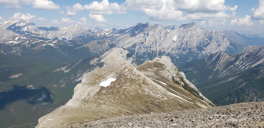
Upon completing the scrambling (or bypassing through the scree), you’ll find yourself at the summit of Opal North Peak, at 2483 m, marked by an imposing cairn. The view is magnificent, with the ridge sprawling below and the surrounding peaks. You may choose to continue along the ridge to reach another (higher) summit, offering more breathtaking vistas. Though optional, this extension is highly recommended.
The panoramic view from the Opal North Peak ridge is spectacular. You’ll catch glimpses of some of Kananaskis’ most renowned peaks.
The return journey follows the same trail, allowing you to relive the highlights of this ascent to Opal North Peak.
TO KNOW
Interest
Difficulty
Distance
Approximately 10.5 km / 6.5 miles
Duration
Around 5 or 7 hours
Elevation
2483 meters / 8146 feet
Elevation gain
Around 1040 meters / 3412 feet
Useful informations
See on Caltopo (detailed)
See on Google Maps (basic)
Useful links
Website: https://www.albertaparks.ca/parks/kananaskis/kananaskis-country/
Parking: https://maps.app.goo.gl/UzKhGSkgptbSqwsy9
Weather forecast: https://www.mountain-forecast.com/peaks/Wedge-The/forecasts/2652
Download GPX: https://www.cnotremonde.com/gpx/Opal-North-Peak-AB-cestnotremonde.gpx


