 New York
Hopkins Mountain
Introduction
Located opposite the most famous peaks of the Adirondacks in the Giant Mountain Wilderness is little-known Hopkins Mountain. Although the summit only reaches an altitude of 962 meters (3,156 ft), Hopkins offers a breathtaking view at a reasonable distance with a gradual climb. You will not regret visiting this charming and low traffic forest trail with its viewpoints, waterfall and river.
We stumbled upon this charming place and the images we captured speak for themselves: It’s a real favourite for C’est Notre Monde.
3D interactive map
Things to Know
To enjoy your hike, you must:
Be equipped: Good hiking shoes are recommended, although the trail presents no particular difficulty. Water of course (3L per person). Pack for a picnic at the top of the mountain to enjoy while facing the magnificent view.
Be informed: Little information is available on this hike. C’est Notre Monde has gathered below what we found helpful to enjoy this hike.
Parking: There is limited parking available located along the road about 1.6 km (1 mile) past the popular “St. Hubert Parking Area”. Be careful not to park in unauthorized areas. Many signs have been posted along the roads, and the police are quick to issue tickets on weekends.
The Hike
The start of this trail is not well indicated. It is located on the side of the road, 1.6 km (1 mile) after the very popular St-Hubert parking lot. You will find it on your right, just before the bridge which crosses the Ausable River. There is no check-in station to register hikers here, you begin your hike directly by following the river before entering the forest. With only one trail on this mountain there is little chance of getting lost. However, be mindful in autumn and winter when leaves or snow cover the trail. There are few markers or signs posted on surrounding trees to indicate the trail. A GPS or any mapping application on your cell phone could be of assistance if you find the path challenging to follow.
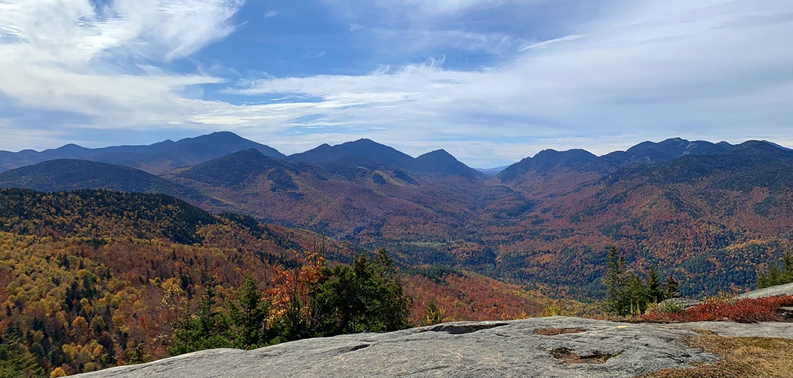
A breathtaking panorama!
The climb is very gradual, you will pass a picturesque waterfall before reaching a charming viewpoint (2.6 km or 1.62 miles from the start). The trail will then begin to climb for the remaining 2.1 km (1.3 miles) to the summit. Just before reaching the top, you will meet an intersection with the sign for Hopkins on the left and Giant on the right. A long, beautiful loop is therefore possible to connect the two peaks. The magic happens when you arrive at Hopkins Ridge, a natural balcony on the massif revealing a magnificent 180-degree view of the High Peaks.
Tip: we came across this trail during a long and busy weekend in the Adirondacks (Thanksgiving). This mountain trail allowed us to bypass the very popular peaks of the massif to discover (with surprise!) a unique view with very little traffic. A summit perfect for late risers looking for superb views and tranquility
After enjoying the view, retrace your steps on the same path, 4.7 km (2.9 miles) to return to your vehicle.
TO KNOW
Interest
Difficulty
Distance
Around 9.35 km / 5.8 miles
Duration
4 h
Elevation
962 meters / 3156 feet
Height difference
Around 700 meters / 2300 feet
Useful informations
The hike in 3D
See on Caltopo (detailed)
See on Google Maps (basic)
Useful links
Parking: https://goo.gl/maps/StdHcN55XoXhBE6d9
Weather forecast: https://www.mountain-forecast.com/peaks/Giant-Mountain/forecasts/1410