 Maine
Maine
Mount Katahdin
Introduction
Mount Katahdin is located in Baxter State Park in the heart of Maine. If you are looking for a peaceful retreat into nature, you are in the right place. Considered one of the most beautiful hikes in the northeastern United States, Mount Katahdin is surrounded by the stunning forests and lakes Maine is known for.
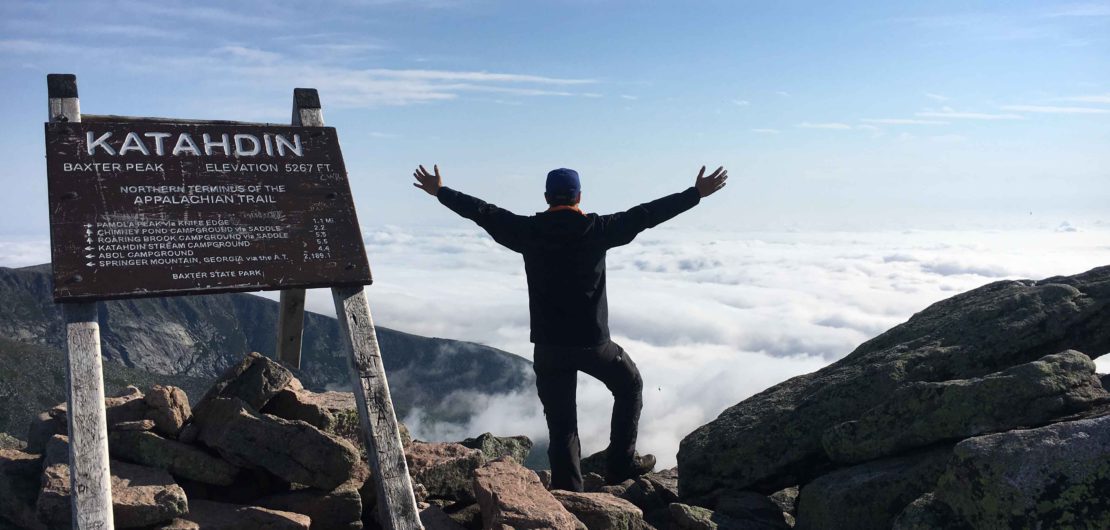
Katahdin, means “the highest mountain”, and at a height of 1606 meters (5269 ft), it is Maine’s highest peak. Easy to believe when observing its massive form several kilometers before entering the park.
For many hikers, it represents an undeniable challenge. Will you dare to walk its rocky mountainside trails? Have you the courage to pass the dizzying Knife Edge ridge? C’est Notre Monde is here to share this thrilling adventure.
Carte interactive 3D
Things to know
To enjoy your hike, you must:
Book your trip: Baxter State Park is only accessible to visitors who have booked their entries in advance on the park’s website. The number of parking spaces is limited because the Rangers want to control the amount of tourist visits to Mount Katahdin for environmental and security reasons. In addition, if you want to camp or rent a lean-to in the park, be sure to book it several weeks in advance. Without a reservation, you will be taking a chance on unfilled spots or cancellations. Be aware, this magical place is very popular in the summer season. The entrance to the park is monitored and accessible only from 7AM to 8PM without reservation.
Be equipped: Climbing Mount Katahdin is long and tiring. Rangers advise hikers to have at least 3 liters of water per person. Believe us, you will need it! If you have one, pack a water filter. If you camp, tent (unless renting a lean-to), sleeping bag, food, and protection from the sun are all necessary. Do not forget to bring garbage bags to leave the park as clean as you found it.
Pay: There is a park fee. Rates are available on the park site.
Be informed: Mount Katahdin is a challenging climb on terrain open to the elements. Do not hesitate to visit the Rangers cabins, in fact we suggest it, to learn about trail conditions and the latest weather forecast. That is why they are there!
The Hike
For the seasoned thrill-seekers, we recommend starting your hike at Roaring Brook Campground east of Baxter Park. Register at the Ranger’s cabin and take the Chimney Pond Trail for 5 km (about 3 mi.) to reach the camp with the same name. This first stretch of the hike consists of well maintained forest trails where you can admire both Basin Pond and Dry Pond. A break is recommended at each pond to admire Mount Katahdin and capture its reflection in the clear waters. This walk to the Chimney Pond Campground takes approximately 2.5 hours with a gain of 450 meters (1476 ft) of elevation. It is a beautiful and pleasant intermediate hike for those who do not plan to summit Katahdin.
Tip: Book a “lean-to” at Chimney Pond Campground. This will prevent you from walking 5 km (3.1 mi.) before the 750 meters (2460 ft) height climb. This will also give you the chance to start your hike at dawn, and increase your chances of avoiding a crowd. We left at 4:30 AM from camp and enjoyed more than an hour of tranquility above the clouds at the top of the mountain. An unforgettable experience!
Upon arrival to the camp, you will find yourself in the middle of a half circle of steep cliffs with your goal in the distance: Baxter Peak. The Chimney Pond Camp is ideally situated at the foot of the mountain. If you decide to camp there for the night you can begin your climb the next day, well rested. You can either pitch a tent or book a “Lean-to” to spend the night under the stars. To do either, register at the Ranger’s cabin in the camp. The Rangers will help you orient yourself, inform you about the state of the trails and update you on the weather forecast. The climb is on open terrain and, therefore, may be subject to strong winds or lightning. Visiting the Ranger’s cabin for information on up-to-date conditions is strongly recommended.
For the climb to Baxter Peak there are two options. The first is Saddle Trail, a 1.8 km (1.1 mi.) walk to reach the ridge. At the ridge, continue your ascent to the summit for the last 1.5 km (0.9 mi.). This trail includes steep sections of rocks. Take care with foot placement to avoid slipping or knocking down rocks that could endanger other hikers behind and below you. The second option is for the more adventurous who do not mind a small amount of bouldering. Take the Cathedral Trail from Chimney Pond Campground, it will take you directly to the summit of Mount Katahdin. During the 2 km (1.3 mi.) climb, this trail exposes you to the mountainside through a beautiful scree, a collection of broken rock fragments. Here you will need to hoist yourself between rocks. Although the path is marked with blue paint, it is easy to find yourself off the trail, confused in this maze of stones. Take care to frequently check the tail markers. In addition, you have to pay attention to the weather. Wet rocks and climbing rarely mix well. Nevertheless, this difficult trail offers a breathtaking view.
Your arrival at the summit of Baxter Peak allows you to admire the beauty of Maine with a 360 degree view. In the distance you will see the “three brothers” and “the traveler” mountains alongside lakes and forests as far as the eye can see. A sign at the top informs you that you are at the edge of the famous “Appalachian trail” that runs through the eastern United States from Georgia to Maine.
After enjoying Baxter Peak, the summit of Mount Katahdin, you can continue to the famous “Knife Edge” which, as the name suggests, is a narrow 1.5 km (0.9 mi.) long ridge that runs along the mountain to Chimney Peak. At such great heights, the Knife Edge trail is not for the faint of heart! At the end of the Knife Edge you can either descend on Chimney Pond Campground by taking the Dudley trail (1.6 km / 1 mi.) or go directly to the Roaring Brook Campground parking lot by choosing the Helon Taylor Trail (5 km / 3 mi.). With the hike now over, you will keep these memories for a lifetime.
TO KNOW
Interest
Difficulty
Distance
14.3 km / 8.7 miles
(Big loop via Saddle trail and Helon Taylon Trail)
Elevation
1606 meters / 5269 feet
Height difference
1165 meters / 3822 feet
Useful informations
See on Caltopo (detailed)
See on Google Maps (basic)
Useful links
Website:https://baxterstatepark.org/
Parking: https://goo.gl/maps/qiDH4o5NEa82
Forecast:https://www.mountain-forecast.com/peaks/Mount-Katahdin/forecasts/1606